1/3


세부 정보리뷰버전정보
1/3
의 설명 Surveyor
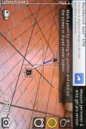
With Surveyor, you can measure distances by placing markers on a virtual ground that is overlaid on the camera image.
Surveyor locks the virtual ground to the real world so no matter which direction you turn to, the markers will always stay where it is originally placed.
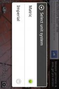
Distances between each markers are calculated and displayed on the screen in the unit system you specified. With the pro version you can place more than 2 markers and even get the area of the space surrounded by the markers.조사선을 사용하면 카메라 이미지에 중첩 된 가상 지상에 마커를 배치하여 거리를 측정 할 수 있습니다.
이 원래 배치하는 위치 마커는 항상 남아있을 것입니다 당신이 설정 방향에 상관없이 그렇게 측량은 현실 세계에 가상의 땅을 잠급니다.
각 마커 사이의 거리가 계산하고 지정된 단위 시스템의 화면에 표시됩니다. 프로 버전을 사용하면 2 개 이상의 마커를 배치, 심지어 마커로 둘러싸인 공간의 영역을 얻을 수 있습니다.
Surveyor - 버전 2.5.2
(14-02-2013)좋은 앱임을 보장합니다이 어플리케이션은 바이러스,멀웨어와 기타 악의적인 공격에 대한 보안 시험을 통과하였으며 어떠한 위험요소도 포함되어 있지 않습니다.
Surveyor - APK 정보
APK 버전: 2.5.2패키지: com.miian.android.surveyor이름: Surveyor크기: 598.5 kB다운로드: 1버전 : 2.5.2출시 날짜: 2020-12-05 09:46:14최소 스크린: SMALL지원되는 CPU:
패키지 ID: com.miian.android.surveyorSHA1 서명: 97:D2:B3:1C:36:DC:75:B3:D7:BD:10:80:AC:E8:FD:4F:66:DA:83:0B개발자 (CN): Li Xuan단체 (O): miianWorks Studio로컬 (L): 나라 (C): 주/시 (ST):
동일 카테고리의 앱
좋아할 만한 것...

English


